


Murray Voting District, Newton County, Arkansas
About
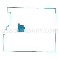
Outline

Summary
| Unique Area Identifier | 527463 |
| Name | Murray Voting District |
| County | Newton County |
| State | Arkansas |
| Area (square miles) | 16.72 |
| Land Area (square miles) | 16.68 |
| Water Area (square miles) | 0.04 |
| % of Land Area | 99.79 |
| % of Water Area | 0.21 |
| Latitude of the Internal Point | 35.94490910 |
| Longtitude of the Internal Point | -93.32724100 |
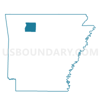
Maps

Graphs
Select a template below for downloading or customizing gragh for Murray Voting District, Newton County, Arkansas


Neighbors
Neighoring Voting District (by Name) Neighboring Voting District on the Map
- Hudson Voting District, Newton County, AR
- Jefferson Voting District, Newton County, AR
- Lincoln Voting District, Newton County, AR
- Low Gap Voting District, Newton County, AR
- Ponca Voting District, Newton County, AR
- Van Buren Voting District, Newton County, AR
Top 10 Neighboring County Subdivision (by Population) Neighboring County Subdivision on the Map
- Hudson township, Newton County, AR (327)
- Jefferson township, Newton County, AR (284)
- Low Gap township, Newton County, AR (268)
- Lincoln township, Newton County, AR (248)
- Van Buren township, Newton County, AR (185)
- Murray township, Newton County, AR (172)
- Ponca township, Newton County, AR (158)